


Description
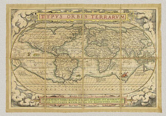
Mappamondo Antico Diviso nell’uno e nell’altro Continente di G. M. Cassini – 1801, original enraving hand watercolored.
The graphic representation of terrestrial shape goes back many years in spite of man’s scarce geographical knowledge, limited knowledge of mathematical and geometrical equations and the lack of accurate means of measuring. All these factors made it difficult to even attempt to create cartographic representations. The first sketches were created because of man’s thirst for knowledge and these artifacts precede the use of writing; they are schematic representations of clear planimetric details, suitable for finding an already known itinerary. Similar devices, proportioned according to the limited needs and restraints in which primitive people first lived, slowly gave way to more and more expressive descriptions and as the horizons widened together with man’s knowledge and needs, the development of a more stable means of measurement and representation became indispensable. From small, bordered areas to the representation of vast territories to finally a global depiction of the entire terrestrial surface.
The irrational and primitive mapmaking during the Medieval period was made obsolete by the spread of the Geography by Ptolemy, aided by the invention of the printing press, (1446). Although this work analyzes and describes those parts of the Earth then known, it also defines its general foundation and the system of enlarging the Earth’s representation in a logical way, thanks to the news geographical discoveries. At the end of the 15th century, the concept of the world being round was well accepted by the most important figures of the time as well as having been proved by the great sea voyages that took place after the discovery of the Americas. Therefore, more precise geographic corollaries and research on more efficient instrumental means were developed.
But it was only in the 18th century that the shape of the Earth became truly defined. After having perfected measuring instruments and obtained an international organization of specialized studies and geodetic measurements, the creation of large national maps and cartographic representations embraced the world known to man.
The little planisphere here riproposed again it is a valid exemplary. It was produced at the end of the 18th century and was printed in Rome at the chamber of copperplate engraving (chalcography).
The technique used in producing this map is the same one used by the antique mapmakers. This includes a manual press, finely engraved plates and pure cotton paper. The paper is then mounted on cotton canvas reflecting the frequently used working procedure employed in the past because it was (and is) necessary to obtain the best preservation possible as well as to insure an easy shipping of the maps. Only the aging process is an operation that our anonymous author would not have needed to use. This is done with a series of all natural substances. Finally the watercoloring gives the work a polychrome vision of indubitable scenic effect. All this work is done in order to produce an object that can bring back the beauty and historical and cultural value of the original, employing the same materials and technique used so long ago.