


Description
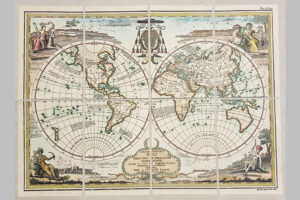
TERRARUM ORBIS by La Feuille Officine Renard
Certainly old maps are among the most fascinating things that the past bequeathed to use. They condens history, art and science in just one hand made and they can comprehend just small territories or the whole known world. They talk to us about the history and evolution of the human being
during the centuries, about his successJul attempts to know the world around him, to describe it and to possess it.
The first attempts to make maps were just schematic representations of planimetric details, useful to recognize and discover an already taken route or a sca-course, however the need of moving in wider places compelled men to look for more stable, surc and precise measuring means.
Re began to consider at first wider and wider territories, then alI the known areas of the earth, examining their form and size and studying the laws of the universe. Owing to the lack of good measuring instruments it was difficult to establish distances or to fix outlines only thanks to earthly routes, almost always irregular and meandering.
In the XV-XVII centuries astronomy, geography and cartography recovered the character of universality in which the ancient Romans lacked and which had been lost during the Middle Ages.
The primitive cartography of the Middle Ages was definitely exceeded by Geografia di Tolomeo, which was favoured by the invention of the press (1446). In these centuries many cartographic ateliers were born, where new maps were made and old ones updated, thanks to the new geographical knowledge, due to the voyages of navigators such as Colombo, Vespucci, Caboto and Magellano.
The XVII century is characterized by many men of science and clever schol-arso This century was marked by the progress of geodesy, thanks to Snellius (Willebrod Snell,Dutch, 1591-1626) who was the first to measure a geodetic “base”.
The planisphere here proposed is made in this storical time (XVIII), realized by La Feuille and printed in Renard’s workshops. It impresses for the refinement of the graphic “art” united with an harmonious composition of the whole.
To prepare this planisphere an old manual press and precisely engraved plates have been used. The support on which the image has been transferred is made up by paper of pure cotton coming from an old paper-mill, which was already working when his work was born for the first time. The sheets manually and one by one undergo a process of ageing based on vegetable substances. Finally, the watercoloring gives the work a polychrome vision of indubitable scenic effect. AlI this work is done in order to produce an object that can bring back the piece’s beauty and historical and cultural value of the original, employing the same materials and technique used so long ago.